
Walk a Lincoln Park Street Record
A street search works best as a chain, not as one all-purpose list. Lincoln Park’s municipal property system begins with the parcel, which can connect a street number to an owner or taxpayer, legal description, sale fields, and building material where those fields are populated. That establishes a land-record starting point. It does not establish that every person at the address lives there now.
Use the same address across independent sources. Wayne County’s map can place the parcel among its adjacent lots. The deed index can establish recorded transfers. A public voter-record request follows a different legal route, and historic reverse directories describe past household listings rather than current occupancy. Keep the date and source beside each result so that a recent assessor entry is not confused with an older directory entry.
- Enter the known address in the Lincoln Park BS&A property search and save the situs address, parcel number, legal description, owner or taxpayer name, and any sale details shown.
- Find the parcel on the Wayne County map, then inspect the same street segment and its adjoining parcel outlines.
- Use the parcel and owner name to locate recorded conveyances in the Wayne County Register of Deeds index. Search both grantor and grantee names.
- For a lawful voter-record need, ask the Lincoln Park clerk for the appropriate jurisdictional public list under Michigan law. The personal voter tool is not a street roster.
- For an earlier household, check the library’s Polk or Bresser material by street address, then compare nearby years for a change in listing.
Note: Each source answers a different question, so agreement across dates is stronger than treating one address result as a complete household list.
Use Lincoln Park Street Directory Fields
The City of Lincoln Park routes current parcel research through BS&A Online. Its property gateway offers assessing, building, current-tax, property-sale, and utility-billing areas. For a street directory search, choose the address route first. If the exact number fails, broaden only as the live form permits, then verify the resulting property card with the assessor because the city warns that posted data can be incomplete or inaccurate.
See the Lincoln Park BS&A property gateway before entering an address, owner name, or parcel number.
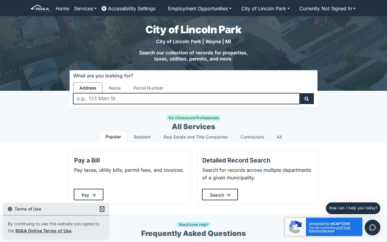
The gateway is the practical start for a current Lincoln Park street directory search, but an empty field or missing detail is not proof that a parcel or historic record does not exist.
| BS&A field | Input | Required | Street-search use |
|---|---|---|---|
| Address | Text | Optional | Use a street number and name, or broaden the street name only when the current form allows it. |
| Name or owner name | Text | Optional | Check a surname, initials, and alternate name order after identifying the parcel. |
| Parcel number | Identifier | Optional | Use the exact local identifier as the durable link to GIS and deed work. |
| Building record number | Identifier | Optional | Open a known permit or enforcement record. |
| Search focus | Tab or dropdown | Optional | Choose Assessing, Building Department, Current Tax, Property Sale, or Utility Billing. |
| Search or Clear | Control | Yes to submit | Run the query or remove the current criteria. |
A detail view can include parcel or account information, owner or taxpayer data, land and legal-description fields, sale history, building summary, values, and department tabs. Those are BS&A field families, not a promise that every Lincoln Park parcel will display every value.
Decode Lincoln Park Address Terms
A street number is easy to recognize, but the records behind it use several identifiers. The key is to preserve the parcel number and legal description when copying a result. A street label can change, while a lot, block, subdivision description, or parcel identifier can keep the land trail connected. Lincoln Park Planning and Engineering maintains records for plats, site plans, lot splits and combinations that can help bridge a street address to its land description.
- Parcel
- A tax-system identifier for one piece of land. It is the most useful bridge between the assessor, map, and deed records.
- Situs address
- The physical location of the parcel. It is different from the owner or taxpayer mailing address.
- Plat
- A recorded subdivision map that sets out lots, blocks, streets, and related land details.
- Legal description
- The land description used in deeds and plats, often naming a subdivision, lot, block, section, or boundary description.
- Criss-cross directory
- An address-ordered directory that can point from a street number to a listed head of household or business.
The Lincoln Park Planning and Engineering office is the city contact for plat and development material. That route is especially useful when a deed names land terms that do not resemble the current street address.
Map Lincoln Park Streets in GIS
The Wayne County Parcel Map is the street-scale map companion to the city property record. Its documented search combines Find Address, Tax Parcel, or Road. Zoom and pan along the block, turn on the parcel, address, road, boundary, district, or zoning layers needed for context, and click a parcel where public popup data is available.
The map helps show which parcels touch a street segment and whether a road, alley, park edge, or district line changes the block pattern. It does not replace the city’s current assessment record. Wayne County says local communities prepare current assessment and tax rolls, so verify an owner or value returned in a map popup through Lincoln Park BS&A.
For a repeatable street directory note, record the map date, street segment, parcel ID, situs address, and the layers used. That creates a useful trail without claiming that a map identifies every member of a household.
Note: The live ArcGIS viewer is dynamic, so its currently available buttons and layer names should be checked before relying on a saved map view.
Trace Lincoln Park Deeds by Street
For ownership history along a Lincoln Park street, start with the present parcel and then move from the current owner to the acquisition deed. In a deed, the grantor transfers an interest and the grantee receives it. Search the current owner as grantee, note the prior grantor, then search that earlier name as grantee to continue backward. When names vary, use the parcel and legal description to keep the chain on the same land.
The Wayne County Register of Deeds search service gives free name-only grantor and grantee index access. Paid on-demand searching adds address, legal-description, parcel or tax-ID, liber or page searches, and document images. The web service covers January 1, 1960 forward. Earlier work requires the Detroit office or a detailed search-by-mail request, where the legal description is especially important.
Mortgage and discharge records can help date activity, but a conveyance deed is the record that carries the ownership trail. A recorded owner is still not a complete statement about current residents at the address.
Check Lincoln Park Address Events
Permits and code records can add dates that a property card does not. In the BS&A Building Department area or through the Lincoln Park Building Department, an address-keyed file may show a permit number, project address, work or inspection type, applicant, contractor, issue date, or inspection status. A certificate or enforcement action can also place a property event at a point in time.
Those records describe property activity and the responsible party recorded for that event. They should not be treated as a census of everyone present at an address. The city counter and a written Michigan FOIA request are documented fallback channels when a public city file is not available through the online system.
Lincoln Park Street Names Since 1956
Street names can make an older Lincoln Park address look unfamiliar even when the parcel trail is sound. City code says that street and alley names accepted as of January 1, 1956 remain in place unless the council changes them by resolution. That is a continuity rule, not a claim that every earlier informal name or address label has been cataloged.
No complete citywide renumbering ledger or verified renumbering year was located. When an old directory or deed stops matching a modern number, compare the subdivision, lot and block, legal description, parcel ID, plats, and council material before assuming an address was renumbered. Older records may also use Ecorse Township or a subdivision name instead of Lincoln Park.
Lincoln Park Street Records at a Glance
No single Lincoln Park street directory lists every person tied to every address. The public record sets below are address keyed in different ways. Start with the parcel record, then use the right follow-up source for the question at hand. The parcel number and legal description are the strongest connectors between the city property card and the county deed chain.
| Address record | Custodian | What it can show | Available channel |
|---|---|---|---|
| Property and tax record | Lincoln Park assessor through BS&A | Owner or taxpayer, mailing and situs addresses, parcel, legal, sale, building, and value fields when loaded | Public portal, assessor verification, historic field sheets |
| Parcel map | Wayne County GIS | Parcel outlines, addresses, roads, boundaries, and district layers | Public interactive map and county GIS materials |
| Recorded deed | Wayne County Register of Deeds | Grantor, grantee, recording date, instrument, and land description | Free name index, paid expanded search or images, counter, mail |
| Building or code file | Lincoln Park Building Department | Permit, inspection, enforcement, project, and responsible-party details where public | BS&A, city counter, or FOIA request |
| Registration record | Lincoln Park clerk and Michigan elections system | Public registration information subject to redactions and protected-address rules | Personal MVIC service or lawful public-list request at cost |
| Historic directory | Lincoln Park Library and other holdings | Address-to-listed household information for available years | Library, licensed collection, and historical repositories |
The Lincoln Park Public Library has a local-history context that supports the older address layer. Its combined Lincoln Park, Allen Park, and Melvindale directory run spans 1941 through 1988 with missing years, so compare named volumes when a street entry has a gap.
Keep Lincoln Park Voter Records Separate
Voter information is a separate layer in a Lincoln Park street directory search. The Michigan Voter Information Center lets an individual check personal registration, polling place, ballot, and local-clerk information. It is not an unrestricted address-by-address roster.
Michigan public registration records can be requested through FOIA, and MCL 168.522 allows a clerk with a computerized voter file to provide names and addresses for specified city, school district, ward, or precinct geography at the cost of making, certifying, and delivering the list. The research did not locate a current Lincoln Park order form, fee, or delivery schedule. Ask the clerk for those details rather than assuming them.
Driver-license and state-ID numbers, month and day of birth, phone numbers, and protected participant information are not public list fields. Michigan does not register voters by party, so party affiliation is not a resident attribute to infer from a public registration record.
Lincoln Park Street Directory Limits
A property owner, tax mailing address, deed grantee, historic directory listing, and voter registration each describe a limited record event. None automatically proves who is physically present at an address today. Public property records also do not reliably identify every non-owner occupant. Utility and delivery-customer details are not a public street directory, and motor-vehicle information is restricted by the federal Driver Privacy Protection Act.
Michigan’s Address Confidentiality Program protects qualifying participants through a designated address and mail forwarding system. Protected voter information, sealed and juvenile court matters, restricted vital records, and legally redacted details must remain protected. A missing result can reflect a lawful restriction, an older index gap, or a spelling difference.
Lawful use. Use Lincoln Park address records for personal, lawful research such as family history, property questions, or civic transparency. Michigan stalking laws, including MCL 750.411h and MCL 750.411i, prohibit using information to stalk, harass, threaten, or target a person.
For earlier address listings, the Lincoln Park city directory collections provide the historical shelf without changing the limits of a current street record.